 |
| Garmin GPS 150 |
I am shocked how many pilots are unaware of the seriousness of the situation when all gyro-derived information is lost while flying in Instrument Meteorological Conditions (IMC). If you are unable to determine whether your aircraft is turning, you will shortly end up in a fatal spiral. It doesn’t matter one whit whether you are a brand new instrument pilot or whether you have 3,000 or 4,000 hours of instrument time under your belt. You will be dead shortly.
I have had many opportunities to demonstrate this to numerous student pilots as well as to my high-time pilot friends. My demonstration begins by failing all the gyros including the turn coordinator (or turn-and-bank) while in trimmed level flight, with the pilot under the hood.
In every case, the flight appears to continue normally for a short period of time. Inevitably one wing or the other will drop and a small turn will develop. Having no turn information, no corrective action is taken. As the turn develops, the nose begins to drop and the airspeed begins to increase. The pilot will usually recognize those cues that something is happening and will increase the back pressure on the yoke in an effort to stop the increase in speed and loss of altitude.
 |
| Cessna 337 Skymaster |
This is the beginning of the end. As he pulls back on the yoke, this causes the bank angle to increase. When the bank angle increases the airspeed accelerates even faster. By now altitude is being lost at a greater and greater rate and he begins to pull back on the yoke with an ever increasing force.
This can generate enough load to fail some portion of the aircraft structure resulting in loss of control of the aircraft and certain death.
In order to maintain control of our aircraft while in Instrument Meteorological Conditions (IMC) conditions, it is absolutely necessary to have turn information. We normally obtain this information from the directional gyro with supporting information from the attitude indicator and turn coordinator instruments. But what if they fail?
Lets see if there is another source of information in our cockpits that can provide turn information. There are in fact, several in most of today’s aircraft.
Global Positioning System (GPS) as a heading indicator
Like many of you, I was an early adopter of Global Positioning System (GPS) navigation for aircraft. And it did not take me long to see the value of using the turn information created by these systems as a substitute for turn information generated by gyros.
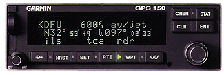
In fact, I just returned from a flight in my Cessna 182P that validated the theory. I had a flight instructor as a safety pilot. While flying solely by reference to instruments, the attitude indicator, heading indicator, turn coordinator and magnetic compass were all covered. My sole source of turn information was the left/right "needle" of the Course Deviation Indicator (CDI) built into my Garmin GPS-150. And this proved sufficient information—along with the altimeter, airspeed and vertical speed indicators—to prevent the aircraft from entering deadly spiral.
In fact, I had the instructor simulate moderate turbulence with inputs from his yoke and was able to maintain straight and level flight. Like most GPS receivers, my Garmin GPS-150 is equipped with the ability to update information at the rate of once per second. This rapid update ability gave me the sensitivity needed to prevent the spiral developing.
In fact, I believe that any GPS receiver could serve in this capacity, even the portable hand held units as long as it had the rapid update capability. Even a LORAN would probably work, although not as well because it’s update rate is slower.
Recently, I purchased a Garmin GPSMAP-195 handheld. This magnificent device combines an extraordinary 12-channel GPS receiver with a remarkable high-resolution graphic display. And one of the "pages" that the device can display is an electronic Horizontal Situation Indicator (HSI) display which mimics the functionality of a panel-mounted HSI with uncanny precision…right down to its settable heading bug!
In the event of a pitot tube or airspeed indicator failure, the GPS groundspeed could be used as a rough speed reference. And if the static system or altimeter failed, the GPS altitude readout can provide an adequate altitude reference, give or take a couple of hundred feet.
Clearly, a modern GPS receiver is useful for more than its intended navigation purpose and could serve a pilot well in the event almost any conceivable flight instrument failure. And now that GPS is found in almost every aircraft, pilots should be trained in using the GPS for this purpose.
Interestingly enough, there has been some experimental work done recently with GPS-based attitude indicators. If you mount a GPS antenna on each wingtip and program a GPS receiver to monitor both antennas and compare the "GPS altitude" of the two wingtips, the GPS can display roll attitude quite accurately. It turns out that Selective Availability and other GPS errors cancel out, since you're only interested in the difference between the altitudes of the two wingtips, not the actual altitudes!
So it's entirely within the realm of possibility that GPS may replace all gyros in our panels of the future...or that gyros may be considered backups for the GPS (instead of the other way around).
The "whiskey compass" as a backup
The magnetic compass is another source of turn information that is little used. The reason is that most pilots promptly forgot everything they learned about magnetic compass turning and acceleration errors about five minutes after they passed their instrument checkride.
The most important thing to remember about the magnetic compass turning errors is what the compass does when you’re on a southerly heading in the northern hemisphere: the compass leads any turn by approximately your latitude. (I.e., if your present location is 30 degrees north latitude, the compass will lead your turns by approximately 30 degrees.)
The amount the compass leads your turn is not nearly so important as the fact that it is indicating a turn in the correct direction.
In other words, the magnetic compass can and does provide correct turn information while on a southerly heading. If you can manage to turn your aircraft to a southerly heading before all your gyro-derived information is lost, you should be able to prevent the development of the deadly spiral by reference to the magnetic compass.
Whenever I demonstrate the ability to maintain control under the hood solely by using the magnetic compass, I usually end up flying a series of shallow banked turns to the left and to the right, but in general maintaining a southerly heading. These are the result of using the compass to indicate when it is necessary for me to input aileron control to stop any turn that develops.
When the compass stops indicating a turn, I neutralize my aileron input. However, I have usually input more control than necessary to stop the turn and end up making a turn in the opposite direction.
 |
| Boeing B-17 |
I must give credit for my source of information about using the magnetic compass as a turn information source to a World War II B-17 pilot whose name I have forgotten. He was a featured speaker at some long-ago luncheon and related how this technique got more than one battle damaged aircraft to safely descend through IMC conditions to Visual Flight Rules (VFR) conditions where they could then safely navigate to their home bases.
|
|
|
|
|
|
|
|
|
To complete this discussion of the magnetic compass, you will recall the magnetic compass will lag any turn while on a northerly heading. In fact it will not indicate any turn at all while on a northerly heading until a heading change of approximately of 30 degrees has occurred if the turn is a very small bank angle.
The magnetic compass will, while on an easterly or westerly heading, incorrectly indicate a turn due to acceleration or deceleration. If you are on a westerly or easterly heading, acceleration will indicate a turn towards the north. Conversely, if you are on an easterly or westerly heading, deceleration will cause the magnetic compass to indicate a turn towards the south.
It is important to note that there is no acceleration or deceleration turning error while flying either a northerly or southerly heading. While flying a southerly heading (in the Northern Hemisphere) the magnetic compass will actually lead any turn and indicate the turn is occurring in the proper direction. In fact, you might consider the compass as extremely bank-angle-sensitive in the proper direction while on a southerly heading.
 |
| Automatic Direction Finder (ADF) By King Radios |
To complete this discussion of alternative turn information sources found in today’s cockpits, I would point out the Automatic Direction Finder (ADF) found in many aircraft is an excellent source of heading information in the event of loss of all gyros. Simply tune the radio to some facility more-or-less ahead of the aircraft and use the needle to provide your needed turn information.
|
|
|
This article was published by Avweb in 1998 and can be viewed at:


